With the upcoming hurricane season right around us, I want to amplify a bit for you some of the background research we do along with why I am very concerned about the Eastern Seaboard in the coming few years.
I think this cycle of concern has not reached what is a natural, forecastable peak, but I am going to show the relationship between the 1950’s hurricanes and the coming cooling of the Atlantic Ocean. While it is starting now, the warmest water ends up near the East Coast while the cooling develops to the northeast. It happened very similar to this in the late ’50s and ’60s! I feel it’s important our readers and objective people in the climate/weather argument understand how climatology is linked hand in hand to the weather. I have made past events the foundation on which I stand today to reach for tomorrow.
I believe there is a great climatic shift occurring now. The last time we had this was when the Pacific warmed in the late ’70s, and as the Atlantic cooled, the emphasis of strongest tropical cyclones relative to averages shifted into the Pacific Ocean from their relative home in the Atlantic Basin (next to averages) that we saw between the ’30s and ’60s. Part of the “shock” of the last almost 20 years of hurricane activity in the Atlantic Basin was that storms occasionally reached land with the ferocity of the storms in the ’30s-’60s. Truth be told though, the landfall intensity – the most telling metric of what tropical cyclones are actually doing – is nothing like the years 1931-1969. Those decades gave us over 35 major landfalls. The decades since, even with more years? Only 20! You simply cannot compete with the magnitude of ’38, ’44, the sisters of ’54, Donna in 1960, along with Carla, Betsy and Camille in the 60s in the gulf. Katrina, Rita and Wilma gave them a run but they did not reach land with the ferocity of Carla, Betsy and Camille. While we are all acquainted with Andrew, the 1947 hurricane was arguably as bad or worse at West Palm Beach. Carla and Betsy were Category 4s, and Camille was a 5. The Labor Day Hurricane of 1935 is almost beyond belief. The 1933 hurricane attack on Virginia Beach, with hurricane winds to Long Island and today’s population build up, would do tens of billions of dollars of damage, and a landfall at the mouth of Delaware Bay could be a $100 billion storm as it was larger and stronger at the core than Sandy. You can go on and on, but the stats speak for themselves. Those four decades blow away the following four. And the most reliable metric is not what a satellite says out in the water, but what it reaches land at. The simple reason: We have always had the metric of landfalling intensity!
That said, as Arctic ice starts to increase and we start pulling into an era where cooling is the missive, keep in mind that in 1957, before we had satellites, we had actual articles like this about the North Pole melting.
You should read the link. It puts some things in perspective.
But now the shift is on the way, and as so often happens in many things, the last part of a certain situation can have fits of “desperation” as the old gives way to the new. Without trying to get too “heavy” here, it seems that man and nature share a common thread when the old guard is falling away. I don’t know if you spent much of your weekend watching a lot of the great old narratives about Memorial Day and what it really means. But when covering the major military actions of our nation’s history, it seemed like many of the worst atrocities by the previously ruling despot occurred as the changes were becoming obvious. I am always analyzing everything that comes in front of me and trying to make sense out of linkage. But there is a reason that someone came up with the idea that it’s darkest before dawn. My point is sometimes the end of an era – be it in the natural flip in climate cycles, or in the case in some of the things that happen to men, individually and in society – have some of the most extremes that a given situation has to offer. After all it is change that produces conflict.
But here we are with Arctic sea ice heading back above normal in the summer melt season and with good reason: The northwest Atlantic is cooling.
The situation in the 1950s can be likened to facing the New York Yankees Dynasty teams of that era. Someone was going to hit you. You simply cannot run the water temperatures in the Atlantic like this and not expect something to hit the U.S. That said, as bad as it was, I think the reason there were not more total storms was because the sea surface temperatures were so distorted – so warm to the north that it lead to hurricanes being less intense in the deep tropics, but having more bang as they came to the coast.
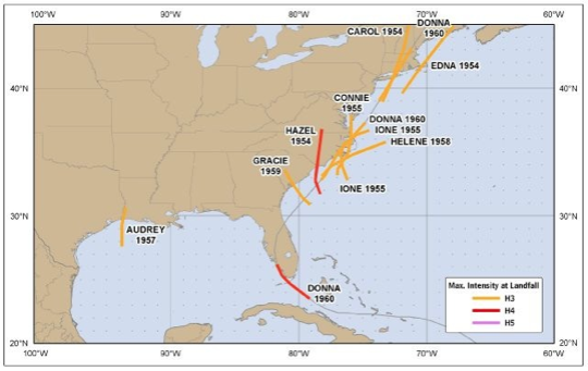
While readers here have seen this many times, here again is the road map of major hurricanes up the East Coast between 1951-1960.

How people claiming today is worse, given the facts of this era, if baffling to me, and makes no sense when compared to reality.
I am using May through July to show the set up. Here is how warm the water was before the hurricanes hit.
1951-1955:

1956-1960:

Notice what is starting to happen in the northwest Atlantic. The tiny cool patch in the front five years is now much bigger. This second map, with all the warming around Greenland, includes 195, – the same year referenced in the article above.
Now watch the water temperatures between ’61-’65.
Let’s remember that Category 4 Esther roared north at Cape Cod in 1961 and weakened while still in an area where the storms of ’38, ’44 and ’54 remained strong. Donna of course in 1960 had to fight a lot of land. But Esther was a monster – a 927 mb, 145 mph killing machine as she made her turn, and not only did she loop away, but weakened as she came toward the loop. A wild track, but when she finally hit, she was a spent nor’easter and not much more.
As bad as it was, it could have been worse had it hit 150 miles further west, coming all the way to New England even as it was weakening. It’s almost unbelievable given the previous eight years what was possible during this time, and how much less we have gotten away with so far. I almost feel like I am writing that Philadelphia Story scenario again, which warned that a storm had to eventually come from the southeast like Sandy, only years earlier. But in this case you have to seriously ask yourself why there have not been more hurricanes. You are facing the equal of the Yankees lineup, and though it’s probably in the 5th or 6th inning, the game’s not over yet.
Now watch the cold water expand between 1966-1980.
The reason to shut the deep tropics down now was the cooling there too. Yet the East Coast dodged a bullet in 1966 when Faith recurved and Doria weakened moving all the way to the coast in 1967. Faith was tracked to the North Pole, and if you want to see a wild track, look at Doria, which almost wrote the Philadelphia Story in the ’60s (cool, dry air in mid-September did her in).
 Gerda in 1969 exploded as she came up the East Coast with 120 mph winds at Nantucket Light Ship, but missed wide right so that leftover warm water near the East Coast had some close calls.

But the cooling set in, and the Arctic ice increased quite a bit. The last time it was above normal in summer was in 1996.
The model runs continue to increase the positive anomaly at the height of the melt season.

But look at how cold the water was during that time. Only Bob and Gloria managed to make inroads up the East Coast until 1996, but those storms did not have major impact north of the Carolinas.

But you can see why hurricanes were less frequent during this period.
Since then we see that the Atlantic went into its warm cycle, but the water off the East Coast in May has not been that warm at all since 1997.

This may explain the lack of this period as of yet challenging the 1950s, and that theory may be getting tested soon. As the northwest Atlantic starts to cool, we are left with the warmest water relative to averages in the Atlantic Basin next to the coast.

It’s all natural. While one may gawk at the warmth, the cooling now starting is the beginning of the end of the period of peril. But in the meantime, this is one forecaster that is extremely worried that we have not faced the peak or the period of peril on the East Cost. The heart of the Yankees lineup is coming to the plate, and it’s the 1950s again.
Joe Bastardi is chief forecaster at WeatherBELL Analytics, a meteorological consulting firm.

Formerly the Chief Long Range Forecaster at Accuweather, Joe Bastardi is an institution in the science of weather prediction. Many companies across a multitude of industries, from energy to retail, have profited from his forecasts.